-
Introduction
-
Database Application
-
Overview of Commands
-
Layout
-
Electric
-
Evaluation
-
Data Export
-
Presentation
-
Analysis
-
===============
-
FAQ – Frequently Asked Questions
-
-
- How is the calculation of the row distance / shadow cast?
- How can I add a prototype-drawing to Helios 3D?
- What does the message “This drawing was last saved by an earlier version of one of the following products:” mean?
- How can I improve the performance of huge projects?
- Why does the Selection Dialog for Prototype Drawings not appear?
- Why are Project Numbers not Managed automatically?
-
Common Erros
-
Step-by-step Tutorials
-
Useful Hints and Tips
-
Releases
- Helios 3D Update 2026.0.1.5
- Helios 3D Update 2026.0.1.4
- Helios 3D Update 2026.0.1.3
- Helios 3D Update 2026.0.1.2
- Helios 3D Update 2026.0.1.1
- Helios 3D Update 2026.0.1.0
- Helios 3D Update 2025.0.1.4
- Helios 3D Update 2025.0.1.3
- Helios 3D Update 2025.0.1.2
- Helios 3D Update 2025.0.1.1
- Helios 3D Update 2025.0.1.0
- Helios 3D Update 2024.0.1.7
- Helios 3D Update 2024.0.1.6
- Helios 3D Update 2024.0.1.5
- Helios 3D Update 2024.0.1.4
- Helios 3D Update 2024.0.1.3
- Helios 3D Update 2024.0.1.1
- Helios 3D Update 2024.0.1.0
- View all articles ( 3 ) Collapse articles
Analysis
Here, you can add and manage terrain analysis results, enabling a detailed evaluation of the surface characteristics and their impact on the project layout.
Add Terrain Analysis

This function allows you to generate a terrain analysis for a web browser in the upcoming dialog and then transfer the result back to the CAD system. If a browser export has not been initiated yet, this function can optionally start the export process as well.
Delete Terrain Analysis

This function deletes the result entry and its associated contents for the selected terrain analysis.
Freeze Results

This function freezes the layers of any analysis displayed in the list below, preventing further changes or updates to those layers while keeping them visible.
When a terrain analysis is added, the calculation occurs in the web browser view. If no active connection to a running browser export is found, the system will initiate the browser export process. Once this is done, the following dialog will appear.
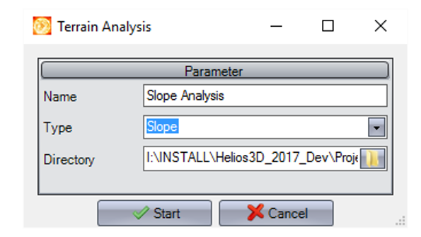
Name
Enter a name for the analysis. The result will be displayed under this name in the Helios 3D palette.
Type
Select the type of analysis you want to start by clicking . The result will then be transferred to and displayed within the application.
Directory
Choose the directory where the result file will be saved. By default, the result image will be saved to the project folder.